In ‘What if the Knesset went local?’ we have mapped out 120 theoretical single-seat constituencies in Israel to model the result of the last Knesset Election in 2015 under a first-past-the-post system.
Israel of course has no electoral constituencies, no area based parliamentary seats. The entire country is treated as a single electoral unit. Parliamentarians are elected through a Party List System.
Our 120 constituencies are home to all the eligible voting citizens of the state of Israel residing in ‘Israel proper’, the West Bank and the Golan Heights. We have however included one group not currently entitled to vote in the Knesset election – the Palestinian municipal residents of east Jerusalem (some 280,000 residents).
Using the Israeli census data to first create 120 Knesset seats of equal population, we then extrapolated the voting behaviour in those theoretical 120 single-seat Knesset constituencies using ‘small area’ election results.
Our 120 Knesset is a simple model. The party that wins a majority or plurality of the vote in each seat wins the seat. We cannot of course, assume that voting behaviour would not have changed, perhaps dramatically so in such constituencies.
It is highly likely that in such a ‘first past the post’, winner-takes-all system that voters of smaller parties would gravitate to a larger party to ‘block’ the election of their least preferable rival grouping. Neither, however, can we presume how that coalescing around like-minded larger groups might manifest itself. In our simple model we therefore assume no change in the first-preference vote. It’s worth stressing that the 2015 Knesset election is itself just a once-off electoral snapshot.
A first-past-the-post system generally favours both larger parties and parties with concentrated or regional support. So, what would a 120 single seat constituency Knesset electoral geography have looked like in 2015? And how would it compare to the current representation in outgoing Knesset?
Our first-past-the-post electoral model leads to a dramatically changed Knesset landscape.
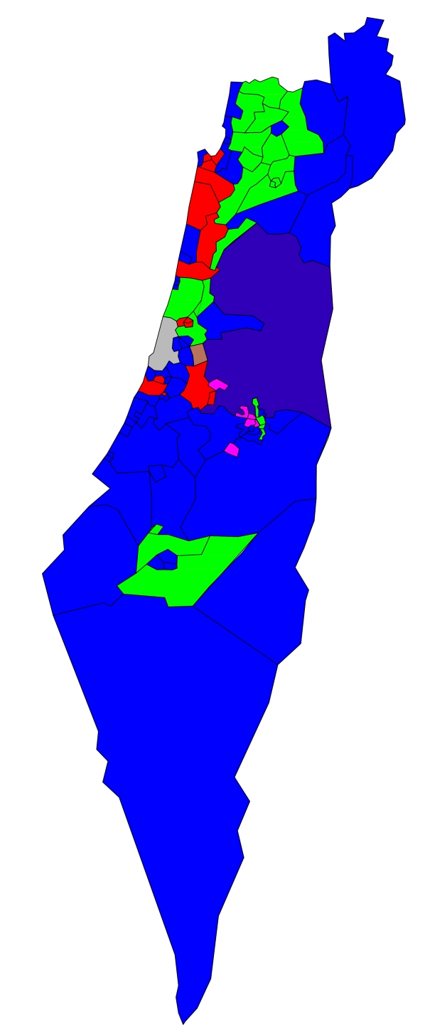
The Likud Party (Blue in map) would see its seat share rise from 30 to 60 (one seat short of an overall majority). Securing an overall majority on a relatively low plurality of the vote is not uncommon in first-past-the-post systems.
In 2005 the British Labour party secured a 66-seat overall majority (55% of the parliamentary seats) on just 35.2% of the national vote. In 1993 the Progressive Conservative Party of Canada famously lost 154 of its 156 seats despite winning 16% of the national vote. In the same election Bloc Québécois with its vote concentrated in Quebec secured 38 seats on just 13.5% of the national vote.
In our first-past-the-post model, the small and medium-sized parties with evenly spread voting support – Yisrael Beiteinu, Kulanu, Meretz, Yesh Atid – would vanish altogether.
The Joint List (Green in Map) a party with concentrated regional support in the Palestinian population centres of the Galilee and Bedouin Negev (potentially in east Jerusalem in our model) would see its seat share rise from 13 to 25, equaling that of the official opposition Zionist Union (Red in Map), which would gain just one additional seat putting the party on 25.
United Torah Judaism (Pink in Map), with concentrated support in religious Orthodox cities, would gain eight seats compared to just six in the 2015 Knesset elections under the existing electoral system.
Our First Past the Post-Election Result; 2015 Knesset Election
(+Gain/-Loss on the Actual Result)
Likud 60 (+30)
Zionist Union 25 (+1)
Joint List 25 (+12)
United Torah Judaism 8 (+2)
Habait Hayehudi 1 (-7)
Shas 1 (-6)
Others 0 (-32)
An additional dramatic change would be the emergence of a new electoral landscape.
Israel would be confronted for the first time with a spatial and very visual electoral geography. The map shows a nation of Likud blue, urban concentrations of Labour in and around Tel Aviv and Haifa, with isolated pockets of religious and right-wing parties clustered in and around Jerusalem. Habayit Hayehudi (Dark Blue) would secure the large sprawling seat of Samaria-North West Bank. Shas (Brown in Map) would pick up a seat in Elad.
With no constituencies and therefore no maps, the Palestinian Joint List was largely ignored on election night in Israel in 2015. Despite getting 13 seats and achieving 3rd party status, the party was deemed largely irrelevant to the pundits discussion primarily because it was not seen as a potential coalition partner for the centre-left.
Another important and dramatic difference in a first past the post system (especially on election night TV screens) would be the visual and psychological impact of the extent of regional concentration of Joint List in Palestinian areas in the north and Bedouin areas in the south of the country. The very territorial integrity of the Jewish state would be questioned.
Perhaps for this reason alone, Israel is unlikely to ever adopt a constituency based electoral system for its parliamentary elections.
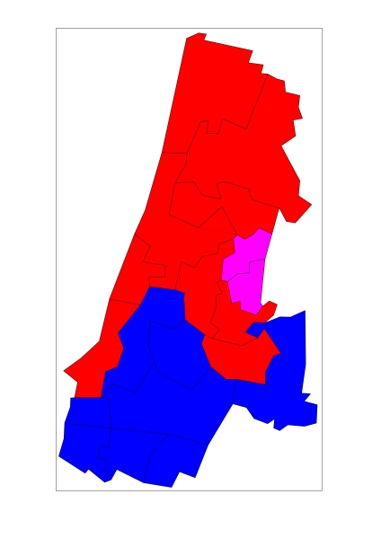
The Tel Aviv District (Inset – Map Below) effectively splits Zionist Union (Red) to the north and Likud (Blue) to the south with United Torah Judaism (Pink) winning the two seats of Bnei Brak.